By: Patricia Santogrossi

Self-Organizing Maps (SOM) is a relatively new approach for seismic interpretation in our industry and should not be confused with seismic inversion or rock modeling. The descriptions below differentiate SOM, which is a statistical classifier, from seismic inversion.
Seismic Inversion
The purpose of seismic inversion is to transform seismic reflection data into rock and fluid properties. This is done by trying to convert reflectivity data (interface properties) to layer properties. If elastic parameters are desired, then the reflectivity from AVO must be performed. The most basic inversion calculates acoustic impedance (density X velocity) of layers from which predictions about lithology and porosity can be made. The more advanced inversion methods attempt to discriminate specifically between lithology, porosity, and fluid effects. Inversions can be grouped into categories: pre-stack vs. post-stack, deterministic vs. geostatistical, or relative vs. absolute. Necessary for most inversions is the estimation of the wavelet and a calculation of the low frequency trend obtained from well control and velocity information. Without an accurate calibration of these parameters, the inversion is non-unique. Inversion requires a stringent set of data conditions from the well logs and seismic. The accuracy of inversion results are directly related to significant good quality well control, usually requiring numerous wells in the same stratigraphic interval for reasonable results.
SOM Seismic Multi-Attribute Analysis
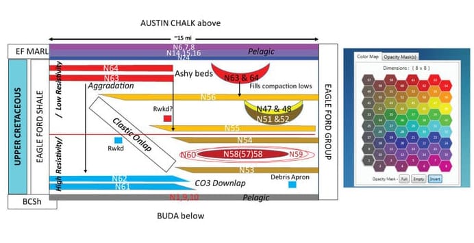
Self-Organizing Maps (SOM) is a non-linear mathematical approach that classifies data into patterns or clusters. It is an artificial neural network that employs unsupervised learning. SOM requires no previous information for training, but evaluates the natural patterns and clusters present in the data. A seismic multi-attribute approach involves selecting several attributes that potentially reveal aspects of geology and evaluate how these data form natural organizational patterns with SOM. The results from a SOM analysis are revealed by a 2D color map that identify the patterns present in the multi-attribute data set. The data for SOM are any type of seismic attribute which is any measurable property of the seismic. Any type of inversion is an attribute type that can be included in a SOM analysis. A SOM analysis will reveal geologic features in the data, which is dictated by the type of seismic attributes employed. The SOM classification patterns can relate to defining stratigraphy, seismic facies, direct hydrocarbon indicators, thin beds, aspects of shale plays, such as fault/fracture trends and sweet spots, etc. The primary considerations for SOM are the sample rate, seismic attributes employed, and seismic data quality. SOM addresses the issues of evaluating dozens of seismic attribute volumes (Big Data) and understanding how these numerous volumes are inter-related.
Seismic inversion attempts to invert the seismic data into rock and fluid properties predicted by converting seismic data from interface properties into layers. Numerous wells and good quality well information in the appropriate zone is necessary for successful inversion calculations, otherwise solutions are non-unique. For successful inversions, wavelet effects must be removed and the low frequency trend must be accurate.
SOM identifies the natural organizational patterns in a multi-attribute classification approach. Geologic features and geobodies exhibit natural patterns or clusters which can be corroborated with well control if present, but not necessary for the SOM analysis. For successful SOM analysis the appropriate seismic attributes must be selected.


