Summary
The present work arises from the need to understand the structural and stratigraphic features of the Arenas del JSO deposit, for the location of new development wells, since one of the last wells drilled, failed to reach the deposit, due to unforeseen geological column; additionally identify if there is communication between two blocks of the same reservoir, so it began with the quality control of the data, where different seismic volumes and well information were analyzed. Multi-attribute analyses were performed on the scale of the sampling interval and bin size to detect lithological contrasts and differentiate the lateral and vertical distribution of sedimentary facies. The thickness of the sand is similar to the traditional intonation thickness or vertical seismic resolution of a quarter of the dominant wavelength. The attributes analyzed were: Amplitude, Bandwidth, Imaginary Part, Instantaneous Frequency, Relative Acoustic Impedance, Envelope, Envelope First Derivative, Envelope Second Derivative, Sweetness and Thin Bed Indicator, among others. The first step was to apply Principal Component Analysis (PCA) to identify the most contributing and significant attributes in terms of variance, to select them as input data for simultaneous classification using an artificial intelligence algorithm known as Self-Organized Maps (MAO). Through this methodology it was possible to extract more information from the seismic data, petrophysical, sedimentological and reservoir analyses were integrated to determine the direction of the deposit of the sands, their vertical and lateral limits, as well as the possible risk zones and areas of opportunity for the best development strategy of the field.
Introduction
The storage rock of the study area is subdivided into five units. Several studies have been carried out to describe the sedimentary process; in 1991, a paleo coastline was drawn taking as a criterion sands that did not present cementitious, product of a process of great energy capable of washing, rounding and selecting the sediments, placing them in an area of beach and / or dunes. In addition, a sedimentological model was made that locates the deposit within a system of transgressive barrier islands. In 1994, it was proposed that the alignments of the stratification planes defined in the image records confirm that, for the most part, sandstone bodies have a great similarity to dune systems in wind environments and there is sedimentation of other coastal subenvironments such as beach front, tidal channels, characteristic of coastal systems. In 2012, it was proposed that the sands of interest were deposited in a transitional environment typical of coastal areas, dominated by tides and was carried out in a transgressive system, constituting a rhythmic alternation of sands and evaporites, forming coastal bars that restricted the circulation of waters giving rise to the formation of evaporitic basins. For the present work, in an integral way, the analysis of electrofaces and the analysis of seismic multiattributes with a focus on lithological contrasts were carried out, to finally, the facies maps were made, which served as a guide for the estimation of properties within the geocellular model. Leal et al., (2019) demonstrated how the application of artificial intelligence for multi-attribute analysis and the integration of multidisciplinary information allowed to increase the certainty about the lithological contrast in an oil field.
Methodology and Results
In the present work, the stratigraphic model was updated from the geophysical records, specifically, at the lowest points of Gamma rays (marking the beginning of a grain-decreasing pattern in the stratigraphic sense) or higher (marking the beginning of a grain-increasing pattern in the stratigraphic sense).
In relation to petrophysics, models of clay volume, porosity, permeability, water saturation, capillary pressure-type of rock and wettability were generated, identifying the petrophysical cuts necessary to obtain the net thickness and net thickness impregnated.
Additionally, maps of electrofaces were generated, as well as gross thickness,
net thickness, effective porosity and permeability, from the results of the petrophysical evaluation, to finally generate the facies maps for each stratigraphic level, supported by the seismic multi-attribute analysis that allowed to define with greater certainty the lateral and vertical extension of the sedimentary facies.
Regarding the dynamic analysis of the reservoir, PVT analysis was performed, its gradient and recovery factor were validated, as well as the production of half of the available wells was forecast using data from the initial period of natural flow and the original reserves were calculated.
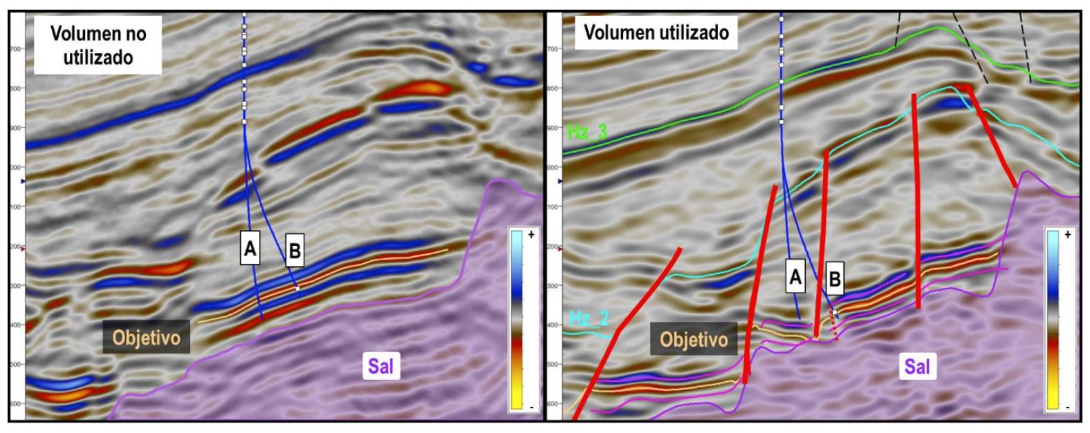
Regarding the structural model, the review and quality control of six (6) different seismic volumes of amplitude was carried out, both in the time domain and in depth, synthetic seismograms were generated and horizons and failures were interpreted that allowed to adjust the structural framework. To the left of Figure 1, a vertical section is observed, which includes wells A and B, proposed with a seismic volume different from that used in this work. Note that in this volume it is not possible to define the faults that delimit the blocks; well A was drilled finding a low block, product of existing faults and found an unforeseen geological column while well B was drilled in the high block, but it remained navigating closely and parallel to the fault plane (Figure 1, right) this generated that it did not find good quality of rock, resulting in wells of zero commercial value. In addition to interpreting the horizons of interest, the same was done for supra and infralysing levels where important changes in velocities were observed, which were used to build a robust model of velocities to carry out the conversion of the time domain to depth.
The next step was the application of the neural network with the Self-Organized Maps (MAO) algorithm to classify different seismic attributes at the voxel scale (12.5 meters by 35 meters and sampling interval equal to 2 milliseconds), which allowed to reveal clusters below the intonation thickness. Prior to this, principal component analysis (PCA) was performed to identify the most contributing or significant seismic attributes in terms of variance. From a total of 13 attributes, it was possible to obtain an ordered list from highest to lowest according to the percentage of total contribution of each attribute with which the graph in Figure 2 was obtained.
Note that in Figure 2, there are at least three groups of attributes after they were sorted, represented by green trend lines: the first group consisting of 4 attributes, the second by 3 attributes, and finally the rest. Thus, the most contributing attributes are: the highest and lowest contribution of group 1 and the highest contribution of groups 2 and 3, respectively (in that order: Instantaneous Frequency, Sweetness, Envelope and Bandwidth).
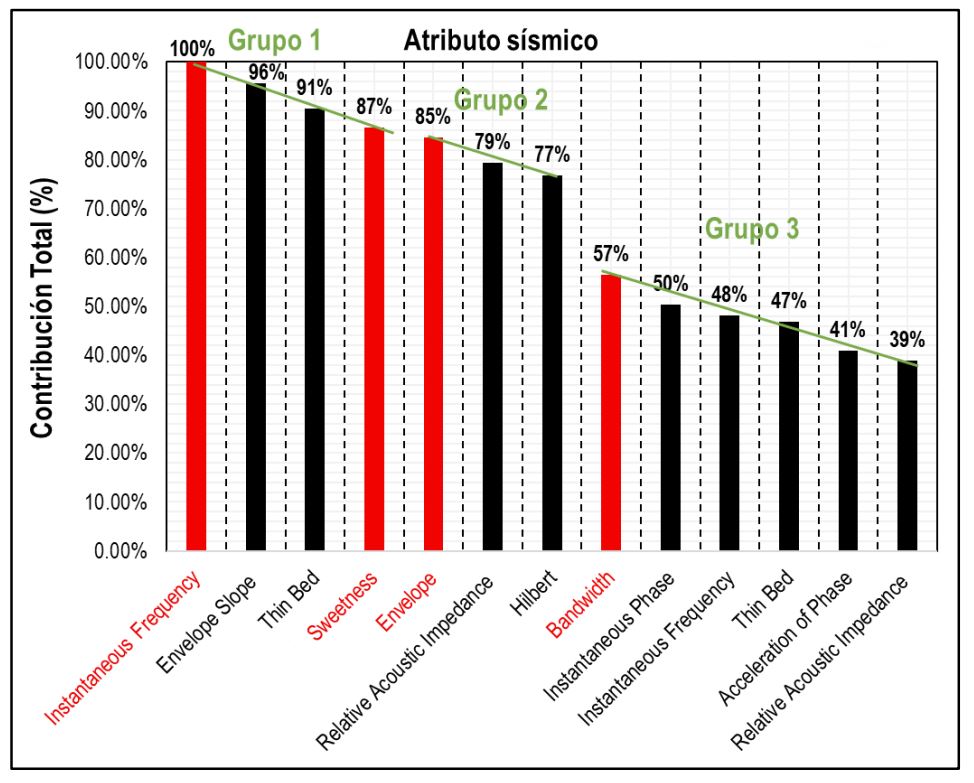
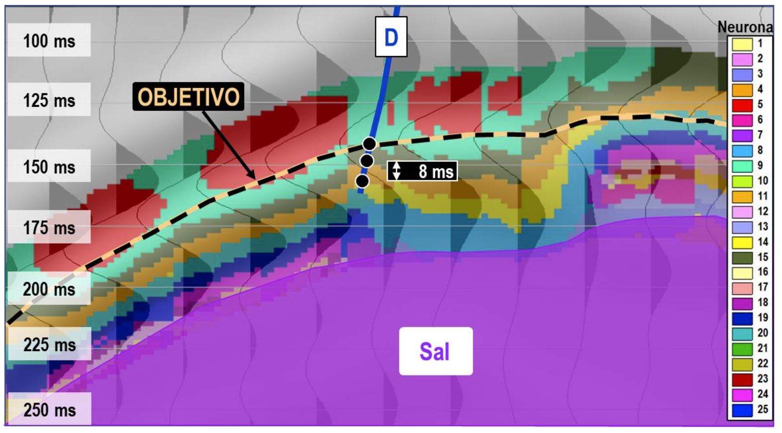
Figure 3 shows the MAO classification at the scale of the sampling interval (2 milliseconds) of 25 discrete values (neurons) and shown with equal amount of colors. In turn, the traces of amplitude are superimposed, in black. In the MAO volume, the voxels grouped by neurons N15 (olive green) and N4 (orange) that correspond to the two upper units of the deposit, whose thicknesses are around 20 meters each, are observed towards the top of the site. Infralysing these units, samples were grouped that are associated with other units, which have, according to well data, lower rock quality than the overlying units, for example, neurons N14 and N20.
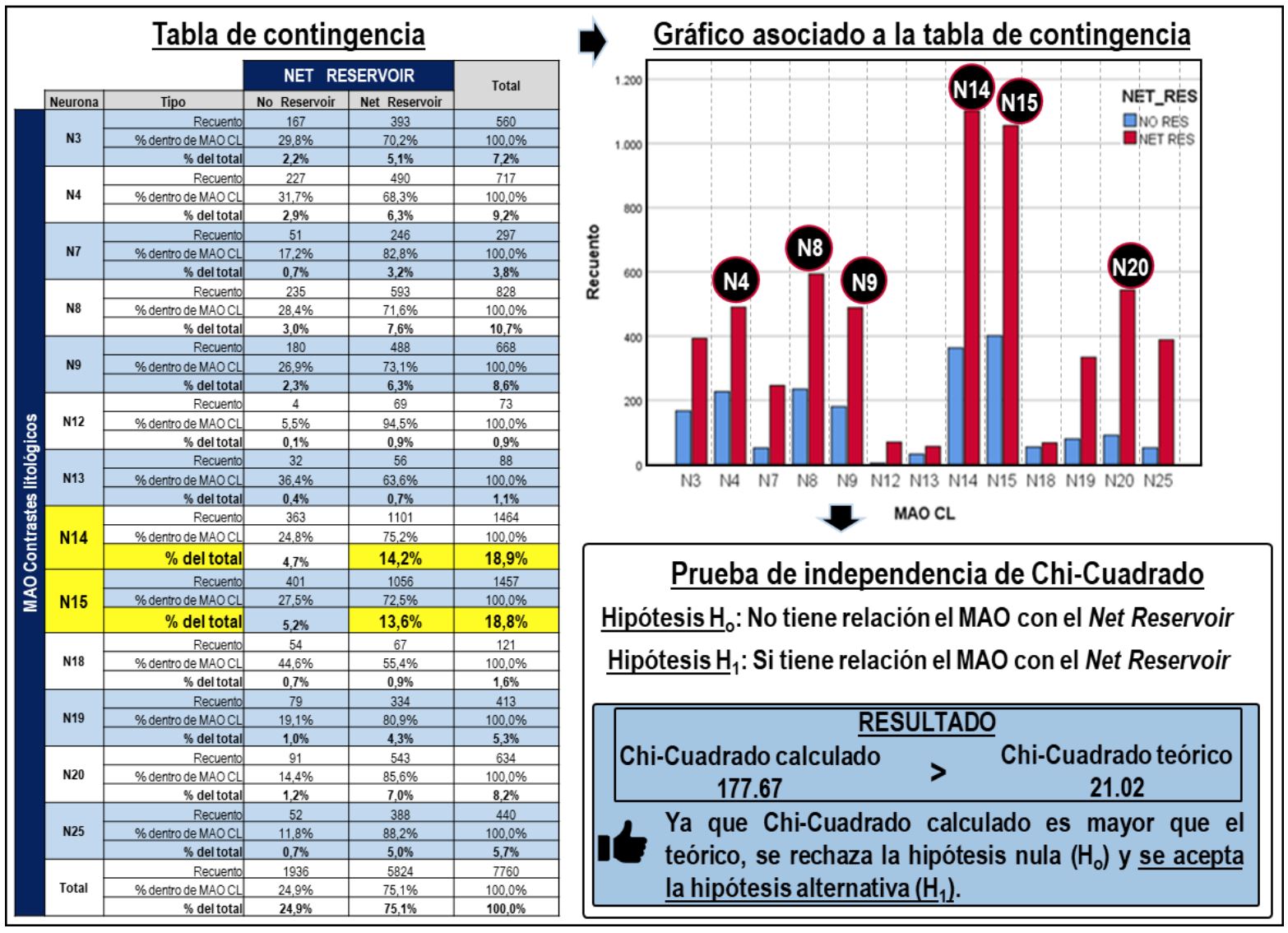
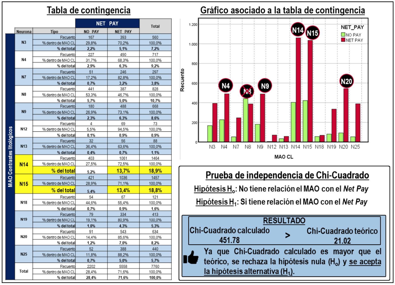
Then the Chi-Square statistical independence test was applied to the wells available in the area, to evaluate whether or not there is a relationship between two categorical variables (Leal et al., 2019), firstly, between the MAO classification of lithological contrast extracted along the trajectories and the sampling interval of the wells (0.1524 m) and the discrete record of the Net Reservoir petrophysical property. With this test the null hypothesis (Ho) establishes that both variables are independent and, on the contrary, the alternative hypothesis (H1) establishes that both variables are related, that is, the neurons of the MAO volume can be explained with the net thickness property (Net Reservoir). In Figure 4, the contingency table and its bar graph are shown, tools with which it was analyzed that the neurons with the highest count in the wells analyzed and that respond in a greater percentage to the Net Reservoir category are the neurons N14 and N15, although there are other neurons that also present importance such as the N8 neuron, N20, N9 and N4. Finally, it is observed that the calculated Chi-Square value is greater than the theoretical value, therefore, the alternative hypothesis is accepted establishing that the variables are related.
It is important to note that, although the mao approach generated mainly seeks to analyze lithological contrasts, it is not ruled out that the MAO responds to the possible presence of fluids, since the classified attributes are frequently used to try to observe changes in the frequency and bandwidth of the seismic signal that could be related to accumulations of hydrocarbons. Based on this, the contingency table analysis and the Chi-Square test (Figure 5) were performed to estimate the relationship between the categorical variable MAO classification and the discrete record of the petrophysical property impregnated net thickness (Net Pay). The result shows that neurons N14 and N15 have the highest count in the Net Pay category and, therefore, are associated with oil-impregnated rock. It is notable that the N8 neuron, which had a high net thickness count (See Figure 4) no longer responded well to Net Pay, this is because this neuron is related to the deeper units of the reservoir whose water saturation values are higher than the cut-off value, this means that it has storage capacity, but it does not contain oil.
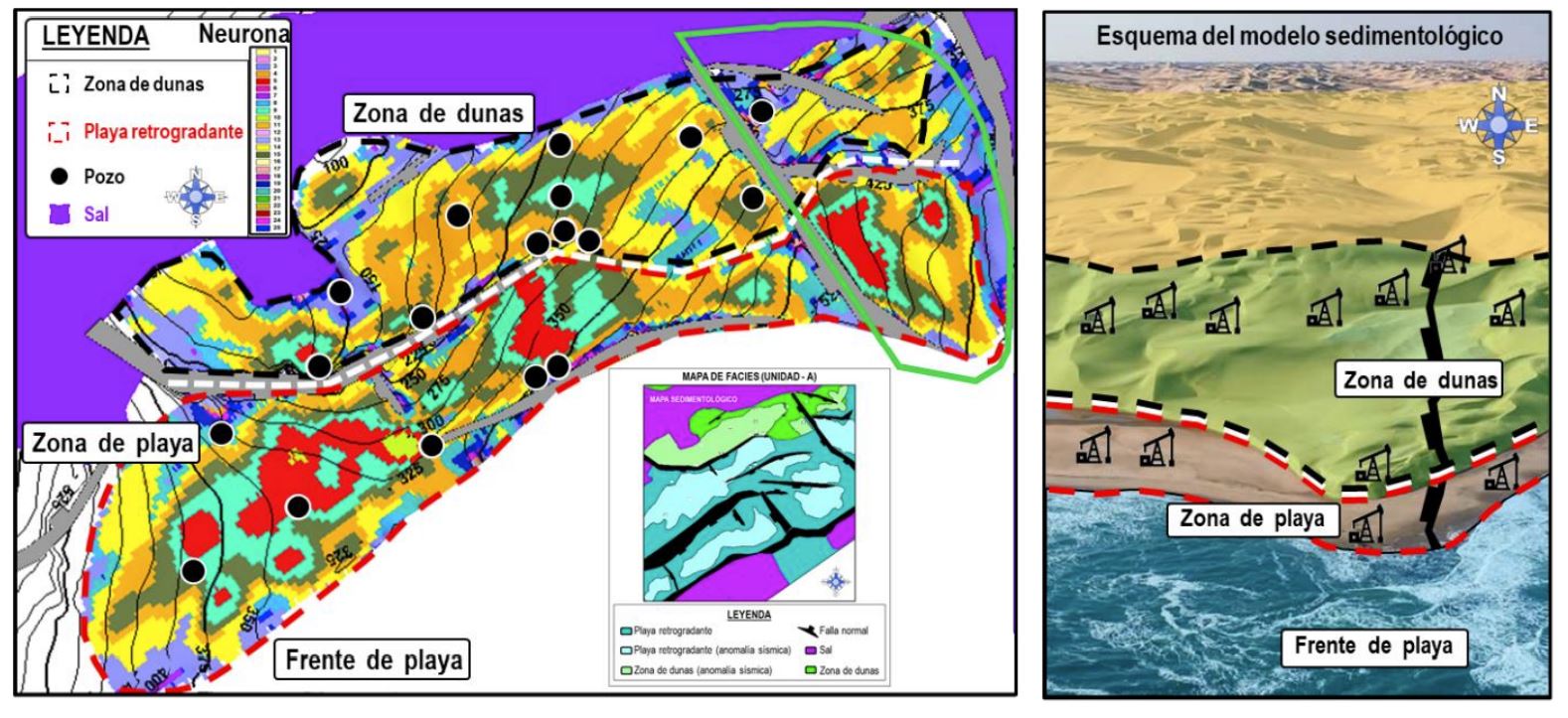
With the help of the MAO classification volume of lithological contrast it was possible to define the geometry of the facies in the maps that formed the sedimentological model for each unit. In the left part of Figure 6, the plan view of a map with the MAO classification at the top of the seismic horizon is shown, with which two trends were defined, the first of them to the north, corresponds to the dune area that, in general, has better rock properties than the rest of the facies, while the second trend corresponds to the beach area, within the dotted red polygon. The different sedimentological studies carried out to define the deposit environments in the study area agree that the units were deposited in coastal environments. On the right side of the figure, a simplified scheme of the analogous sedimentological model is observed, in which areas with the identified facies and the relative position of the wells are shown.
Additionally, from these results the geometry of the block to the east of the map was delimited, which had not been previously conceptualized. In the study area, the results allowed to detect five (5) areas of opportunity, of which two (2) had not been identified, which could help maintain or increase oil production.
Conclusions
The present work allowed to adjust the structural framework in areas where previously no faults had been defined in the vicinity of wells that were drilled and found unforeseen geological column. Additionally, it was verified by static and dynamic data that the northern and southern blocks are communicated. Principal component analysis (PCA) served to identify and select the most contributing seismic attributes in terms of variance. With the simultaneous classification of four seismic attributes, at the scale of the sampling interval, through the MAO neural network it was possible to delimit the lateral and vertical extension of the reservoir units, under a multidisciplinary integration approach that included petrophysics, sedimentology, stratigraphy, geophysics and reservoir engineering, which allowed to increase certainty about the lateral and vertical extension of the deposit.
Acknowledgements
To the team of PEP and Petroleum Oil & Gas Services, Inc., for providing the technical resources used and to Geophysical Research, LLC (d/b/a Geophysical Insights), for providing the Paradise® software.
References
Leal, J., R. Jerónimo, F. Rada, R. Viloria and R. Roden (2019). “Net reservoir discrimination through multi-attribute analysis at single sample scale”. First Break, v 37, No. 9, p. 77-86.
Roden, R., & Sacrey, D. (2016). Seismic Interpretation with Machine Learning. GeoExpro, 50-53.
Professional career of the author and co-authors:
Madaín Moreno Vidal is a graduate of the National Polytechnic Institute as a Geophysical Engineer, with 25 years of experience as a seismic interpreter and leader of Geosciences in Production Assets of the Northeast Marine Region, he has been the author of several discoveries of fields such as exploratory opportunity and surrounding blocks in fields in production. His experience ranges from the detection and generation of exploratory locations to the strategy in development and exploitation of fields. Additionally, he participated as Seismic Advisor in Rio de Janeiro (2008-2010), and was National Leader of Seismic Interpretation (2010). He is currently Leader of Static Characterization of Deposits of the Ek-Balam Project.
Esteban Martínez is a Geologist Engineer, graduated from the Autonomous University of San Luis Potosí, with 19 years of experience in the oil industry. He worked as a well geologist for 9 years in exploratory delimiter and development marine wells. He has worked in the VCD Group of the Cantarell Production Asset (2010-2015), in the Geosciences Coordination in the Geomodeling area (2015-2017), and from 2017 to the present as part of the Exploitation Geology Group in the Ek Balam Group, monitoring drilling and participating in operational decision-making.
Gustavo Mellín is a Geologist; graduated from the Autonomous University of Guerrero in 2000. He carried out stratigraphy and sedimentology work (2000-2003) in gas exploitation wells (North of the Country) and oil wells (South Zone and Marine Zone). In 2003 he joined PEMEX to the Geological Operation Department (RMSO), in the stratigraphic control of exploratory wells. In 2005 he joined prospectuses and Initial Characterization of the APC performing petrographic-diagenetic and stratigraphic analyses. He has 3 diplomas in his career at Petróleos Mexicanos. He currently serves as leader of the Sedimentology and Stratigraphy group of the Cantarell Production Asset.
Santiago Martínez is a Geologist graduated from the Autonomous University of Nuevo León (2013). From 2013 to 2014 he worked in the north of the country carrying out the geological-operational monitoring of gas wells. In 2015 he joined PEMEX, the APC in the area of Sedimentology, developing activities of stratigraphic control of development wells, updating of sedimentary models and stratigraphic and structural correlations of monitoring wells. From 2017 to the present he works as an Interpreter Geologist in the Ek-Balam Group where he performs VCD work and operational monitoring of development wells and is an active member of the AMGP.
Fabián Rada has 14 years of experience in the areas of seismic interpretation, incorporating techniques such as Principal Component Analysis, neural networks for seismic multi-attribute analysis, Spectral Decomposition, “RGB visual blending” of attributes and geobody extraction, as part of workflows developed for the characterization of hydrocarbon deposits. Previously, he worked at Funvisis, CNPC Daqing of Venezuela and PDVSA Seismic Bielovenezolana. Mr. Rada has experience in the acquisition, processing and interpretation of seismic reflection and refraction, gravimetric and magnetic data. He received the title of Geophysical Engineer from the Central University of Venezuela.
David Rodríguez is a Geophysical Engineer graduated from the Autonomous University of Nuevo León, has more than 13 years of experience in the oil industry working as a seismic interpreter with different tools focused on the analysis of seismic multi-attributes through unsupervised neural networks, also has experience in AVO analysis (modeling and interpretation), seismic investment and handling the tool of propagation of petrophysical properties through networks supervised neuronals. He has also worked as a Senior Geophysical Analyst in time and depth seismic processing and has served as a quality control analyst for terrestrial 3D seismic acquisition.
Reinaldo Viloria is Director of Petroleum Oil & Gas Services, Inc., with 30 years of experience in the oil industry, leading and managing various complex projects in Exploration and Production. His experience includes research, development of methodologies and application of geostatistical techniques for the characterization of deposits in Venezuela, Mexico, Argentina, Colombia, Africa, USA and Canada. Mastery in the integration of multidisciplinary information. Mr. Viloria holds a Specialization in Reservoir Modeling and Characterization from Imperial College london and the French Institute of Petroleum in Paris and a bachelor’s degree in Mathematics from the Central University of Venezuela.


